Latest news

The countryside north of Dorchester and west of Stinsford with it’s heritage and cultural significance and important links to Thomas Hardy, will become part of Dorset Council’s draft Local Plan to build 4,000 houses to meet the government’s massive new housing targets for local authorities.
The Thomas Hardy Society, STAND, and Dorchester Town Council strongly object.
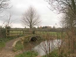
Proposals from developers include the development of 950 acres of land from Charminster weirs to Stinsford roundabout which would ruin the open countryside around the county town. Much of the development would be built on meadowland which floods and the creation of new roads would have a major impact on the environment.
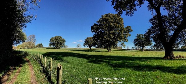
Most of the land planned for development is Grade 3 farmland, and includes land adjoining the River Frome and its floodplain. The ecological survey produced for Dorset Council has identified foraging and commuting bats, hazel dormouse, otter and water vole, slow-worm, grass snake and a range of breeding and wintering birds with the floodplain supporting a range of waders and wildfowl. A number of badger setts have also been identified across the site.
The full report can be found on the Dorset Council website
using the reference P/ESP/2025/04277
This website uses cookies
We use cookies to personalise content and ads, to provide social media features and to analyse our traffic. We also share information about your use of our site with our social media, advertising and analytics partners who may combine it with other information that you've provided to them or that they've collected from your use of their services. You consent to our cookies if you continue to use our website.
OK Accept Cookies
The Thomas Hardy Society is an educational charity supported solely by volunteers. The Society is based in Dorchester where the Council of Management meets six times a year. contact us.
To subscribe to our mailing list and receive news & updates please click here
Mark Chutter, Chairman and Academic Director
The Thomas Hardy Society
c/o Kingston Maurward College
Dorchester
Dorset DT2 8PY
© 2025 The Thomas Hardy Society all rights reserved
No part of this website may be copied or otherwise reproduced without the express permission of the copyright owner(s)